Planning a Pictured Rocks Elopement in Michigan's Upper Peninsula
If you're considering an elopement at Pictured Rocks National Lakeshore, chances are a traditional venue isn't what you have in mind for your wedding day. You're picturing cliffs rising above Lake Superior, quiet forest trails, hidden waterfalls, and shoreline views that feel vast, wild, and completely removed from everyday life.
Located in Munising, Michigan, the park stretches nearly 42 miles along Lake Superior in the Upper Peninsula. It's one of the most visually dramatic landscapes in the Midwest, featuring layered sandstone cliffs, wide beaches, jack pine forests, and backcountry overlooks all within reach.
As a Michigan-based adventure elopement photography team who regularly hikes and explores this stretch of the U.P., we help couples plan intentional, experience-driven wedding days built around the experience rather than just the ceremony. Pictured Rocks isn't just scenic — it requires thoughtful planning around terrain, weather, permits, and crowd patterns.
This guide walks through everything you need to know before eloping at Pictured Rocks, including approved ceremony locations, hiking considerations, seasonal factors, permit requirements, nearby lodging, and the details couples often don't think about until they're standing on the trail.
How to Legally Have a Ceremony at Pictured Rocks
Unlike many outdoor locations, you can't say your wedding vows just anywhere within the park, and it comes along with a few simple but important rules and regulations. The National Park Service only allows ceremonies at two designated sites within park boundaries, and you have to apply for a Special Use Permit. There's a $100 application fee, and we are more than happy to handle the paperwork as a featured add-on to any elopement package. The permit helps protect the fragile landscape while still allowing couples to celebrate in some of the park's most iconic backdrops. You'll fid details on each location below, but first it's important to understand the rules and regulations set by the National Park Service to help protect the fragile landscape.
Special rules & regulations
Guest Limits | Maximum of 40 guests total (including the couple and wedding party)
Chairs & Seating | Maximum of 10 chairs allowed. No permanent seating is provided, and anything brought in must be removed promptly after the ceremony.
Timing | Limited to two (2) hours total, including setup and cleanup. Must occur during daylight hours.
Drones | No unmanned aircraft systems (UAS/drones) are permitted.
Decorations, Signage & Music | Must follow Leave No Trace principles.
- No signs can be affixed or placed on park property
- No items are permitted to be thrown including balloons, confetti, rice, etc.
- No loud music or sounds
- No artificial lighting (including battery or flame lighting)
- Everything must be brought in and taken out during the permitted time
- Nothing may be left behind
- Couples may be charged if cleanup is required by park staff
Miners Beach
Best For | Scenic beach with iconic Pictured Rocks views
Accessibility | Wheelchair accessible from west end boardwalk to platform
Crowd Level | Moderate to high
Terrain | Sand, small stones
Distance from Parking | Short walk
Pet Policy | Dogs allowed on a leash
Features | Boardwalk, picnic area, overlook, small boat friendly (perfect for water-based grand entrances or kayaking portraits!)
Miners Beach features a near mile-long shoreline featuring a sandy beach with two parking areas, with the main lot being on the west end, and a smaller lot on the east end. Take the boardwalk from the main lot through a pine forest leading to a picnic area and small overlook. You'll be able to spot the fittingly named Bridalveil Falls off to the east. Take one of the three staircases leading down to the beach and head to the left for 0.25 miles to where Miners River meets Lake Superior with Miners Castle towering overhead. At the far east end of the beach, you can find the smaller Elliot Falls at the cliff's edge.
COUPLE O' MITTENS TIPS:
- Weekday or sunrise ceremonies offer the most privacy
- Expect wind and waves, can make hearing difficult
- No private reservations are allowed
- Plan extra time for guest arrival and navigation
- Choose suitable footwear for sand
- Consider a first look at a nearby location
Sand Point Beach
Best For | Accessible beach with calmer water and sunset views over Munising Bay
Accessibility | Easy, flat walk from parking (most accessible ceremony spot)
Crowd Level | Moderate (but less crowded than Miners Beach)
Terrain | Sand, some grassy and wetland areas nearby
Distance from Parking | Very short walk
Pet Policy | Dogs allowed on a leash on beach and in water
Features | Pink sand, calm waters, sunset views, mobi mat allows wheelchair access across beach to water's edge
Sand Point Beach is widely considered the most accessible option in the park. Located along the Munising Bay right near the Munising Falls Visitor Center and park headquarters, the beach sits in a protected area where water is typically shallower and calmer. The main beach is a short, flat walk from the parking lot, with seasonal accessibility features in summer and fall including a Mobi mat that crosses the beach to the shoreline, along with a viewing scope in the summer. To reach a bit more privacy and even catch a glimpse of pink-colored sand, you can head to the second beach area about 0.25 miles past the main beach area. Unlike many park locations, Sand Point is accessible year-round by regular vehicle, as the road and parking areas are plowed in winter. A vault toilet is available and open throughout the year.
COUPLE O' MITTENS TIPS:
- Sunset ceremonies are stunning here
- Water is typically calmer and warmer
- Public access remains open during ceremony
- Nearby trails offer great woodsy portraits (no pets)
Best Portrait Locations for Your Pictured Rocks Elopement
One of the biggest advantages of planning a Pictured Rocks elopement is the range of stunning portrait backdrop options within the park. From cliffside overlooks high above Lake Superior to forest waterfalls and wide-open beaches, each location offers a completely different atmosphere.
Some areas require miles of hiking and are ideal for the more adventurous-at-heart. Others are accessible within minutes of parking and work well for couples wanting to bring a small group along with them.
Below we've highlighted some of the best locations for your elopement portraits at Pictured Rocks National Lakeshore, along with what to expect from each.
Chapel Rock & Chapel Beach
Best For | Remote, adventurous portraits with iconic landmarks
Accessibility | Strenuous hike
Terrain | Forest trails to a sandy beach
Crowd Level | Moderate to High
Distance from Parking | 3 miles each way
Pet Policy | No pets allowed
Features | Chapel Rock landmark, Chapel Falls, Chapel Lake Overlook
Suggested Ceremony Location | Miners Beach
Chapel Rock and Chapel Beach are among the most iconic and visually striking portrait locations within Pictured Rocks National Lakeshore, but reaching them requires a bit of commitment. From Munising, drive east on H-58 for roughly 15 miles, then head north on Chapel Road for another 5 miles to reach the trailhead. The final stretch of road is a rough backcountry road that can become congested during the summer and early fall. The parking lot can fill up by 9 AM, so plan accordingly.
From the trailhead, a roughly 3-mile hike leads you out to Lake Superior, passing Chapel Lake and Chapel Falls along the way. The trail includes uneven terrain, elevation changes, exposed roots, and sections can become muddy after rain or snowmelt. Once you reach the shoreline, you'll see Chapel Rock rising dramatically from the water's edge, known for the solo 250-year-old white pine tree with roots connecting back to the mainland. From the beach, you can reach the mouth of the Chapel River meeting Lake Superior. This is the perfect add-on location for couples looking to add the Overnight Backpacking Experience to their elopement day, with a backcountry campsite located nearby.
COUPLE O' MITTENS TIPS:
- Arrive very early as parking lot often fills up by mid-morning
- Plan a full-block of time for hiking in, portraits, and return
- Wear proper footwear and change once you get to the beach
- Bring water and snacks (We're happy to hold onto them for you!)
- Expect cooler temps by the lake
- Best suited for couples comfortable with hiking
- Sunrise and late evening offer the quietest conditions
- Perfect location to work into an Overnight Backpacking Experience
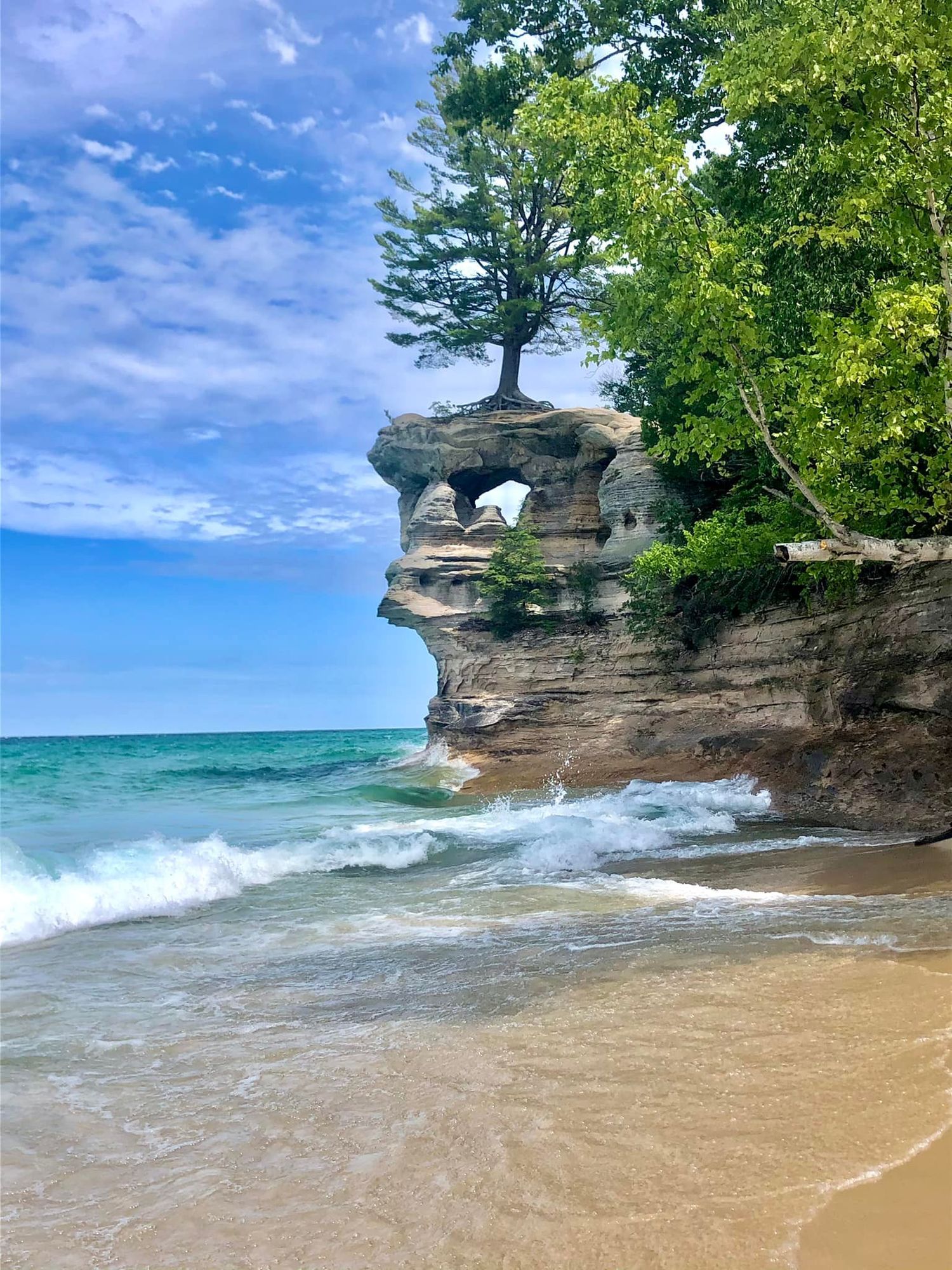
View of the iconic Chapel Rock formation from Chapel Beach
Chapel Loop (multiple highlights!)
Best For | Epic cliff-top portraits and a true backcountry adventure experience
Accessibility | Strenuous hike
Crowd Level | Low beyond main junctions
Terrain | Forest trail, roots, mud, elevation changes, cliffside sections
Distance from Parking | ~10 miles full loop
Pet Policy | No pets allowed
Features | Cliff-top views, rock formations, coves, arches, North Country Trail
Suggested Ceremony Location | Miners Beach
The Chapel Loop is one of the most scenic and demanding hikes within the park. This roughly 10-mile route traverses the Chapel Basin area and follows sections of the NCT high above Lake Superior, offering sweeping views of the cliffs, coves, arches, and rockfalls. Long forest stretches alternate with dramatic cliffside overlooks, and the difficulty keeps crowds lower than at beach destinations. With several backcountry campsites along the route, it's especially well suited for couples planning a multi-day elopement to accommodate the adventure.
COUPLE O' MITTENS TIPS:
- Best suited for couples comfortable with long-distance hiking
- Perfect for full-coverage and overnight backpacking elopements
- Bring plenty of water and food for your trip
- Wear hiking footwear
- Use caution while walking along the cliffside sections
Mosquito Beach
Best For | Dramatic shoreline portraits with sculpted cliffs and fewer crowds
Accessibility | Moderate to strenuous hike
Crowd Level | Moderate
Terrain | Forest trail, roots, mud, sand, rock terraces
Distance from Parking | ~2 miles each way
Pet Policy | No pets allowed
Features | Sandstone terraces, Mosquito River, wildflowers in spring
Suggested Ceremony Location | Miners Beach
Mosquito Beach is a popular day-hike destination within the Chapel-Mosquito trail system and offers some of the most dramatic shoreline scenery outside of Chapel Rock. The trailhead sits at the end of a rough, seasonal backcountry road. From the trailhead, the hike to the beach is about 2 miles each way through a hemlock-dense forest and typically follows the Mosquito River. Wildflowers often pop here in the spring. You can take a spur trail to add on Mosquito Falls for an additional backdrop. Expect and prepare for wet and muddy trail conditions.
COUPLE O' MITTENS TIPS:
- Arrive early as parking fills by mid-morning
- Expect muddy sections
- Wear suitable footwear
- Bring water & snacks (we are happy to carry them!)
- Excellent option for couples wanting scenery without the full Chapel hike
Miners Falls
Best For | Powerful waterfall portraits with easy access
Accessibility | Easy to moderate walk
Crowd Level | Moderate to high
Terrain | Forest trail with stairs to lower overlook
Distance from Parking | 0.6 miles each way
Pet Policy | Dogs allowed on a leash
Features | 50-foot waterfall with upper & lower viewing areas, basin access, spring wildflowers, fall color hotspot
Suggested Ceremony Location | Miners Beach or Sand Point Beach
Miners Falls is the most powerful waterfall in Pictured Rocks, where the Miners River drops 50 feet over a sandstone ledge. The trail to the falls is a gently rolling gravel and dirt path through the forest, making it one of the more accessible waterfall hikes in the park. At the end of the trail, an upper overlook gives a view of the falls from above. A staircase with 64 steps leads down to the lower viewing area closer to the base. For those seeking a more immersive viewpoint, it's possible to carefully climb down a 15-20-ft semi-steep bank that goes down into the rocky basin, just make sure to wear suitable shoes. The surrounding forest is especially vibrant in the spring when wildflowers bloom and again during peak fall color season.
COUPLE O' MITTENS TIPS:
- Plan for early morning or late evening to avoid peak crowds
- Lower platform and basin offer stunning views
- Avoid going into the basin after rain or in icy conditions
- Expect cooler temps and mist
- Bring suitable footwear for mud and loose terrain
- Great add-on location when paired with nearby ceremony spot Miners Beach
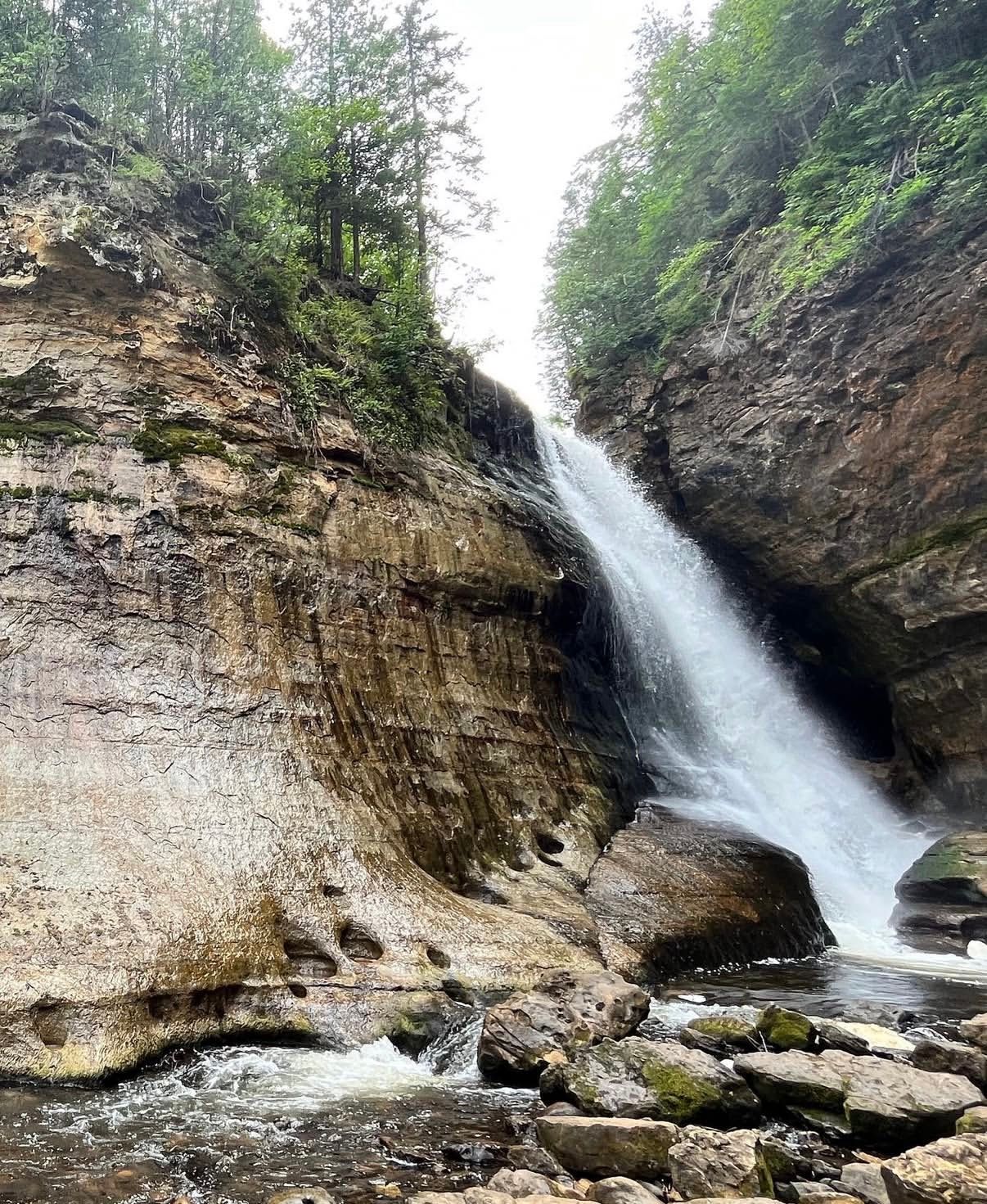
Miners Falls from the lower basin
Log Slide Overlook
Best For | Epic panoramic views and dramatic dune landscapes
Accessibility | Easy walk to overlook
Crowd Level | Moderate
Terrain | Sand dunes, exposed bluff edges
Distance from Parking | Short walk
Pet Policy | No pets allowed
Features | Grand Sable Sand Dunes, view of Au Sable Lighthouse, historic site
Suggested Ceremony Location | Sand Point Beach
Log Slide Overlook sits atop the massive Grand Sable Sand Dunes, ~7 miles west of Grand Marais off H-58. A short walk from the parking lot past old logging equipment brings you right to the edge, where the landscape suddenly drops away into sweeping views of Lake Superior. The scale here is huge and feels completely different from the cliffside areas farther east in the park. In the late 1800s loggers built a wooden chute down this slope to send timber into the lake for transport. From the main overlook, you can climb down the dune for dreamy beach portraits, but beware of the return climb up due to loose sand. Most visitors stick near the top and head to another beach with easier access. Wind is almost always a factor here, and footing near the edges can be unstable.
COUPLE O' MITTENS TIPS:
- Sunset light across the dunes is especially gorgeous
- Wind can be intense
- Climbing down the dune is the optional, easy part, the return climb can be a challenge
- Wear shoes that handle sand well (or none at all)
- Stay back from steep drop-offs
- Great locations for epic, cinematic, windswept portraits
Grand Sable Sand Dunes
Best For | Sweeping sand-dune landscapes and secluded, otherworldly portraits
Accessibility | Moderate to strenuous
Crowd Level | Low to moderate
Terrain | Deep sand, dune climbs, exposed conditions
Distance from Parking | ~0.75 mile or more depending on access point
Pet Policy | No pets allowed
Features | Massive dune field, Lake Superior views, high bluff overlooks
Suggested Ceremony Location | Sand Point Beach
At the far eastern end of Pictured Rocks National Lakeshore, the Grand Sable Sand Dunes stretch across roughly 5 square miles of towering sand shaped by glacial action. Perched atop the 300-ft Grand Sable Banks, this landscape feels more like a desert overlooking the ocean than Northern Michigan. Access is limited, with the most direct route via the Grand Sable Dunes Trail near Sable Falls. The hike is short but involved climbing uphill through soft sand. Another access point near Grand Sable Lake requires a moderate dune climb. Once on top, you'll be rewarded with sweeping views of endless sand and water. Vegetation is fragile, so it's important to stay off the dune grass. Because of the effort required, the area often feels quieter than more accessible parts of the park.
COUPLE O' MITTENS TIPS:
- Walking in soft sand is tougher than it looks
- Wind exposure can be strong
- Bring water and sun protection
- Stay off vegetation
- Best for couples comfortable with physical effort
- Sunrise and sunset offer the best conditions
Grand Portal Point
Best For | Cliff-top portraits with sweeping views of vivid blue water
Accessibility | Very strenuous hike
Crowd Level | Low
Terrain | Forest trails, beach walking, steep climbs, exposed cliffs
Distance from Parking | ~10 mile round-trip (varies by route)
Pet Policy | No pets allowed
Features | Grand Portal Arch View, Indian Head Overlook, Au Train Formation Cliffs
Suggested Ceremony Location | Miners Beach
Grand Portal Point is one of the most iconic and remote viewpoints in Pictured Rocks, offering jaw-dropping views of the cliffs and the bright turquoise water of Lake Superior. Reaching it requires a bit of a hike through the Chapel Basin, making it best suited for couples comfortable with sustained physical effort. From the Chapel Road trailhead, the trail passes through forest before reaching Mosquito Beach. From there, you follow the Lakeshore Trail as it climbs onto the Au Train Formation, where the landscape opens dramatically into high sandstone bluffs overlooking the lake. Along the way, you'll pass major viewpoints, including Indian Head, before arriving at Grand Portal Point.
COUPLE O' MITTENS TIPS:
- Best suited for couples comfortable hiking distances
- Perfect for full-coverage and overnight backpacking elopements
- Bring plenty of water, food, and weather protection
- Wind exposure on cliffs can be intense
- Consider hiking in normal clothes and changing on location
- Multiple scenic stops along the way make it worth the effort
Sable Falls
Best For | Waterfall + Lake Superior views with minimal hiking
Accessibility | Easy to moderate (stairs)
Crowd Level | Moderate
Terrain | Forest path, long staircase, sand and rock beach
Distance from Parking | ~0.4 mile round-tip
Pet Policy | Dogs allowed on leash on steps and trails to the falls and beach
Features | 75-ft cascading waterfall, 168-step staircase, beach, creek, seasonal facilities
Suggested Ceremony Location | Sand Point Beach
Sable Falls is one of the most accessible waterfall locations in Pictured Rocks, where Sable Creek drops roughly 75 feet over layered sandstone continuing to Lake Superior. A short walk from the parking lot leads to a long staircase with 168 steps to the base of the falls for the best view. The trail continues beyond the waterfall to a quiet rock-and-sand beach where Sable Creek flows into the lake. This adds a second scenic setting within a short distance, making it easy to capture both waterfall and shoreline portraits within a short timeframe. Flush toilets and drinking water are available seasonally at the parking area, which is uncommon for many locations throughout the park.
COUPLE O' MITTENS TIPS:
- Staircase is the main challenge, so plan extra time for the return climb
- Lower area can be cooler and damp from mist
- Beach is often quieter than the viewing platforms
- Great add-on stop for eastern park itineraries
- Works well for couples wanting dramatic scenery without a strenuous hike
- Footwear with good grip is recommended
Munising Falls
Best For | Easy-access waterfall portraits with minimal walking
Accessibility | Easy (paved trail)
Crowd Level | Moderate to high
Terrain | Paved path, stairs to upper platforms
Distance from Parking | ~0.2 miles each way (800 ft.)
Pet Policy | Dogs allowed on leash
Features | 50-ft waterfall, paved trail, viewing platforms, year-round bathrooms
Suggested Ceremony Location | Sand Point Beach
Munising Falls is one of the most accessible scenic spots in the park, located right next to the Visitors Center. An 800-foot paved trail follows Munising Creek through a cool, shaded canyon to the base of the 50-ft waterfall. Two staircases lead to additional viewing platforms higher up, offering different perspectives of the falls and surrounding rock formations. The lush canyon is especially vibrant in the warmer months, with ferns, moss, and wildflowers lining the trail. Because of its easy access, this is one of the most visited sites in the park. In the winter, the waterfall transforms into dramatic ice formations, creating a completely different visual experience. Access into or behind the falls is not permitted. Flush restrooms are open year-round, making this one of the few locations in the park with reliable facilities.
COUPLE O' MITTENS TIPS:
- Great warm-up location before heading deeper into the park (we know some of the best parts veering off from the Visitors Center!)
- Expect crowds during peak daytime hours
- Early morning or evening offers the best light and fewer people
- Shaded canyon can feel cool
- Platforms provide multiple portrait angles (bring ice spikes in the winter!)
- Excellent option for couples wanting dramatic scenery with low effort
Au Sable Light Station & Beach
Best For | Historic lighthouse portraits with shoreline and open lake views
Accessibility | Moderate walk
Crowd Level | Low to moderate
Terrain | Gravel access road, sand, rocky shoreline
Distance from Parking | ~1.5 miles each way
Pet Policy | Dogs allowed on leash (light station ground only)
Features | Historic lighthouse, shipwreck remains, river mouth, remote shoreline
Suggested Ceremony Location | Sand Point Beach
The Au Sable Light Station sits on a remote stretch of shoreline about 12 miles west of Grand Marais. Built in the 1870s, the lighthouse stands on Au Sable Point where the Au Sable River meets Lake Superior, creating a striking combination of historic landmarks and rugged scenery. Access requires a 1.5-mile walk along the former Coast Guard service road from the Hurricane River Campground day-use area. The route is mostly flat and straightforward, making it one of the more approachable "remote" locations within the park. At the lighthouse, the landscape opens to a wide shoreline. The setting feels quiet and expansive, especially outside peak summer hours, and offers multiple portrait opportunities without needing additional hiking. Seasonal drinking water and restrooms are available at the station. Biting flies can be intense on hot summer days with a south wind, so preparation is important.
COUPLE O' MITTENS TIPS:
- Plan extra time for the walk in and out
- Sunset light on the shoreline is beautiful here
- Bring layers - for both the wind and the black flies
- Great location for those who love Michigan's history
- Works well as part of an eastern-end adventure day
Choosing Right Pictured Rocks Elopement Location for Your Comfort Level
Not every Pictured Rocks elopement looks the same. Some couples want a sweeping waterfall within minutes of parking, while others dream of a full-day hike that ends on a cliff above Lake Superior. One of the best parts about eloping in Michigan's Upper Peninsula is having options across that entire spectrum.
All ceremony sites in the park are limited to Miners Beach and Sand Point Beach, but portraits can take place anywhere throughout the park depending on your comfort level. From highly accessible beaches to backcountry loops, here's a clear breakdown of portrait locations by accessibility.
Most Accessible Locations
These spots offer strong scenery without committing to miles of trail and work well for relaxed timelines.
- Munising Falls: ~800 ft paved walk
- Sand Point Beach: Short walk from parking
- Miners Beach: ~0.2-0.3 miles from parking
- Sable Falls: Short walk with stairs
- Miners Falls: ~1.2 miles round trip
Moderate Hike, High Reward
These work beautifully for couples wanting a little adventure without committing to a full day.
- Mosquito Beach: ~4 miles round-trip
- Chapel Rock & Chapel Beach: ~6 miles round- trip
backcountry experiences
These locations reward effort with privacy, panoramic views, and a sense of complete immersion. Ideal for couples seeking privacy for portraits.
- Grand Portal Point: ~9-10 miles round trip
- Chapel Loop: 10.5 miles full loop
- Grand Sable Sand Dunes: Soft sand terrain, shorter hike but physically demanding
A Location We Don't Recommend
Miners Castle is iconic, but heavily fenced, structured, and crowded. It's better suited for sightseeing than portraits.
Best Time of Year for a Pictured Rocks Elopement
Pictured Rocks is open year-round, but each season creates a completely different experience. Lake Superior influences everything here - weather patterns, trail conditions, waterfall flow, and crowd levels. Choosing the right season isn't just about the aesthetics. It helps shape your timeline, and overall pace of the day. Below is how the seasons realistically break down the logistics of elopement days in Northern Michigan.
If you're unsure which season fits your vision, we help couples choose based on scenery, privacy, and logistics that best fit your day.
Spring
(Late April - Early June)
Crowd Level | Low to moderate
Best For | Flowing waterfalls
Vibe | Quiet, transitional, bright colors
Spring is when the waterfalls are at their strongest thanks to snowmelt. Trails feel quieter than summer, and the forest begins to regain its colors. Temps are cooler and comfortable for hiking, but conditions can be muddy. Lake Superior remains very cold, and rapid weather shifts are common.
COUPLE O' MITTENS TIPS:
- Mud and lingering snow patches are possible
- Some seasonal facilities or roads may still be closed
- Lake winds feel colder than forecasted
Summer
(June - August)
Crowd Level | High
Best For | Long golden hours
Vibe | Energetic, bright, peak season
Summer offers the longest daylight hours and the most flexibility for planning. Beaches are fully accessible, boat tours run daily, and warm evenings allow for sunrise or sunset timelines without rushing. It's also the busiest time of year, especially at Miners Beach and the Chapel area.
COUPLE O' MITTENS TIPS:
- Parking areas fill quickly
- Try to avoid mid-day ceremonies
- Biting flies and mosquitoes can be intense
- Sunrise/sunset provides privacy
Fall
(September - October)
Crowd Level | Moderate to high
Best For | Vibrant foliage, cooler temps
Vibe | Bold, crisp, dramatic
Fall in Michigan's Upper Peninsula is brief but spectacular. Forested sections of the park glow with color against the sandstone cliffs and deep blue of Lake Superior. Cooler temps make hiking more comfortable, but peak color draws visitors quickly, especially on the weekends.
COUPLE O' MITTENS TIPS:
- Weekday dates offer significantly more privacy
- Peak color timing varies each year
- Weather can shift quickly
- Sunset occurs earlier, shortening your timeline
Winter
(November - March)
Crowd Level | Very low
Best For | Privacy, snowy scenes
Vibe | Peaceful, cinematic, remote
Winter transforms Pictured Rocks into a quiet, snow-covered wilderness, and it happens to be our favorite time to explore here. Frozen waterfalls, ice formations along Lake Superior, and empty trails create dramatic and intimate settings. Access becomes more limited, but we will help you prepare.
COUPLE O' MITTENS TIPS:
- Some roads and parking areas may be inaccessible
- Traction gear like ice spikes is recommended/necessary
- Extreme cold and wind exposure are common
- Have a backup plan
Pictured Rocks Elopement Permit Requirements
Since Pictured Rocks is managed by the National Park Service, there are a few formalities involved, but nothing overwhelming. If you're planning to hold a ceremony inside the park, you'll need a Special Use Permit. As of now, the fee is $100 (always double-check for updates), and the park asks that you apply at least four weeks in advance. If you're bringing guests, setting up anything decorative, or planning to use chairs or an arch, there are specific guidelines around what's allowed and where.
The park is serious about protecting the landscape, and that's part of what makes it so special. Leave No Trace principles are enforced throughout the lakeshore. That means minimal decor, no leaving anything behind, and being mindful of fragile dune and cliff ecosystems. In most cases, elaborate setups aren't necessary anyway. The cliffs, waterfalls, and shoreline already do the heavy lifting for you.
Commercial photography may also require permitting depending on the scope of the day. We stay current on requirements and help couples navigate the paperwork so it doesn't feel like a guessing game. The goal isn't to complicate your day - it’s to protect the place you’re choosing to get married in.
Are Dogs Allowed at a Pictured Rocks Elopement?
“Can we bring our dog?” is one of the most common questions we get — and the honest answer is: sometimes.
Certain areas of Pictured Rocks National Lakeshore are pet-friendly, including many campground areas, select waterfall trails like Miners Falls, portions of Miners Beach, and designated parking and picnic zones. Sand Point Beach is the most consistently pet-friendly ceremony location in the park. Pets must remain on a leash at all times.
However, much of the backcountry, dune systems, wilderness zones, and longer trail systems — including areas like the Chapel Loop and Grand Portal Point — do not allow pets.
Because regulations can change and vary by zone, we always confirm current National Park Service guidelines before finalizing an elopement plan. If including your dog is important to you, we can structure your day around pet-friendly ceremony sites or create a timeline where they're included for part of the experience and cared for elsewhere for the remainder of your day.
It’s absolutely doable — it just requires thoughtful planning.
Where to Stay Near Pictured Rocks National Lakeshore
Pictured Rocks National Lakeshore is located just outside Munising, Michigan, a small Upper Peninsula town that serves as the primary gateway to the park. Nearby communities like Grand Marais and Marquette offer additional lodging options if you prefer a quieter base or a larger town with more amenities, respectively.
CAMPING OPTIONS
If camping is part of your vision, several drive-in campgrounds are located within the lakeshore, including Twelvemile Beach, Otter Lake, North Gemini, and Kingston. These offer direct access to nature but limited services. Backcountry camping is also available with a permit and advance reservation. There are no first-come, drop-in backcountry sites within the park, so planning ahead is essential.
CABIN & VACATION RENTALS
Most couples choose private accommodations in the Munising area for comfort, privacy, and flexibility. The region offers wooded cabins, A-frame rentals, small downtown lofts, and classic log homes tucked into the forest. When planning a Pictured Rocks elopement, we typically recommend a place that allows you to:
- Get ready comfortably
- Write vows privately
- Move slowly in the morning
- Reset at the end of the day
Where you stay becomes part of the story, especially if you're incorporating getting-ready or cabin portraits into your elopement timeline. We are always happy to help couples choose lodging that works seamlessly with their timeline and chosen locations.
Experience Ideas for Your Pictured Rocks Elopement
One of the best parts about eloping at Pictured Rocks National Lakeshore is that your day doesn’t have to revolve around a single 30-minute ceremony. This stretch of Michigan’s Upper Peninsula naturally lends itself to experience-based timelines built around movement, scenery, and most of all, adventure and exploration!
Your day might begin slowly at your cabin, continue with a private vow exchange in the forest, transition to a shoreline ceremony, and end with dinner, a campfire, or stargazing along Lake Superior. Some couples choose to add adventure on the water, while others focus on quieter moments and scenic stops throughout the lakeshore.
EXPERIENCE IDEAS COUPLES LOVE
- Visiting a waterfall before heading to the beach
- Planning a sunrise or sunset hike
- Stopping at multiple viewpoints along the lakeshore
- Kayaking beneath the sandstone cliffs
- Taking a boat tour for water-level views
- Sharing a picnic or champagne on the shoreline
- Ending the night at a local Munising hang-out
- Gathering around a campfire at your cabin
- Stargazing - or Northern Lights viewing when conditions align
BUILDING A TIMELINE THAT FLOWS
The goal isn't to pack in as much as possible - it's to create a day that feels natural and unhurried. We design timelines around hiking logistics, travel time, energy levels, and seasonal logistics so the experience feels intentional rather than rushed. Every elopement day we plan looks different because they're built around how each couple wants the experience to feel.
Our Approach as Pictured Rocks Elopement Photographers
Planning a Pictured Rocks elopement involves far more than choosing a pretty backdrop. Terrain, hiking distance and conditions, weather off the lake, and seasonal conditions all shape how the day unfolds, and we plan around those conditions with intimate knowledge of the area and careful preparation.
We help couples choose locations that match their comfort level and vision. We build timelines around terrain and weather, create backup plans for when that weather shifts, guide you through permit requirements and Leave No Trace practices, and help you prepare so nothing feels uncertain once you're on the trail.
Our familiarity with the park comes from time spent here outside of wedding days. We’ve hiked these trails. We’ve watched the lake sit completely still at sunrise, climbed frozen staircases in winter, and traced the shoreline long after peak season crowds disappeared. That firsthand knowledge matters when building a day that feels steady, grounded, and thoughtfully prepared.
We don’t just show up with cameras. We guide the experience.
If cliffs, waterfalls, forest trails, and Lake Superior stretching endlessly behind you sound like your kind of place, we’d love to help you plan something intentional, rooted in adventure, and fully yours. Contact us to begin planning your Pictured Rocks elopement.
